


Shadow Lake Watershed Action Plan
 A Lake Watershed Action Plan (LWAP) is an assessment and planning tool that identifies the greatest threats to water quality, wildlife habitat, and the overall health of the lake ecosystem. The process evaluates the shoreland, tributaries, drainage ditches, wetlands, hydrologically connected roads, and working landscapes to create a priority list of issues and projects. The result is a planning guide that prioritizes restoration and protection actions for the watershed.
Click here for the Shadow Lake ArcGIS Map Data Viewer to explore maps showing details about the watershed and desktop assessment results.
Click here for the Shadow Lake Data Library to explore existing information about the watershed. Watershed Action Plans Data Library’s are digital library’s with relevant information such as maps of shoreland parcels, lidar topography, land use, water quality data, relevant GIS layers, town infrastructure information, presentations . The information is for interested members of the public, the town, the lake association and others to review including proposed priority areas for assessment.
Explore this Story Map to learn about the work and results of the Phase 1 Lake Watershed Action Plan for the Shadow Lake watershed. You can view the final report here.
Phase 2 Report
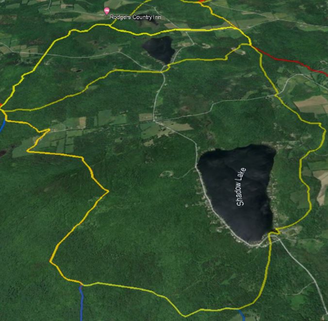
This report is intended to be used alongside the Shadow Lake Watershed Action Plan (LWAP) Phase 1 Final Report completed by OCNRCD and Watershed Consulting in March of 2024. The Shadow Lake LWAP was only partially completed due to funding availability at that time. In Phase 1, the lakeshore, roads, and major stream crossings were thoroughly surveyed, but the streams and their headwaters were not able to be covered. This Phase 2 report attempts to complete the LWAP process and give a full view of the watershed’s water quality threats.
In May 2025 OCNRCD & MWA staff began assessing Shadow Lake’s perennial streams and stormwater inputs to locate contributing sediment sources. These sources are typically areas with accelerated erosion including bank failure, channel headcuts and incision, problematic crossings, and gullying inputs. Rapid stream survey methods were used to evaluate the tributaries. Rapid stream surveys combine data collection methods from the Phase 2 “Lite” Stream Geomorphic Assessments (SGA; VTDEC, 2009) and the VFWD Riparian Streambank Assessment protocols. These surveys map and describe observations such as bank erosion, headcuts, gullies, log jams, beaver dams, stormwater inputs, bank erosion, and grade controls. Rapid stream surveys were completed by walking the streams on foot from the lake outlet to the headwaters.
This work was funded by MWA’s project development grant and the OCNRCD’s lakes capacity grant, both awarded by the Memphremagog Clean Water Service Provider (CWSP) with Leahy Great Lakes Fishery Commission funds. Objectives for these grants include identifying and developing potential projects that aim to reduce phosphorus loading and improve fish habitat. This report along with potential water quality project summaries will be submitted as deliverables for these grants, and made available to VTDEC’s Watershed Management Division.
Community Engagement
Kick off meeting Shadow Lake LWAP one pager and presentation.
Check out the August 2023 public meeting presentation to review of work to date and summary of survey results.
On March 12th 2024 4:30-6:00 we hosted a virtual meeting presentation on the final report.
—To watch the final report presentation recording on YouTube click here.
–Here are PDFs of the presentations from Orleans County NRCD and from Watershed Consulting.