


Small Unmanned Aerial Systems (sUAS) Program
The Vermont Association of Conservation Districts (VACD) aims to use Unmanned Aerial Vehicle (UAV) technology to increase efficiency, save staff time, and improve service to farmers.
UAV technology is multipurpose and can accommodate many project types to aid in real-time data delivery to stakeholders. The VACD sUAS team has been using this innovative technology to acquire up-to-date aerial imagery and elevation data quicker and cheaper when compared to contracting other entities. Capturing up-to-date aerial imagery allows planners, engineers, and wetland restoration staff to monitor change over time without needing to conduct lengthy manual surveys and can be particularly useful in hard-to-reach areas such as eroded streambanks or flooded wetlands.
The VACD sUAS program is led by Luc Burnier and Shannon Harty who both have FAA Part 107 Remote Pilot licenses. Program operations include developing program systems and forms, soliciting and planning projects, interfacing with conservation planners, flying projects, interpreting and sharing resulting data, delivering online and in-person presentations, and preparing program reports.

Conservation Innovation Grant (CIG):
VACD received a Conservation Innovation Grant (CIG) through USDA-NRCS to expand the sUASProgram through the acquisition of the Matrice 300 RTK enterprise drone. This UAV can capture data for longer periods in more variable conditions. The Matrice 300 has Real-time kinematic (RTK) and post-processed kinematic (PPK) capabilities which allows pilots to capture highly accurate data on larger areas with minimal upfront labor costs. Additionally, this UAV allows for camera/sensor interchangeability, such as a multispectral or thermal imaging. VACD acquired a multispectral sensor, allowing for the capture of information outside the visible light spectrum. VACD aims to utilize this sensor to monitor crop heath and efficiently identify invasive species.
The CIG has allowed VACD and the USDA-NRCS partnership to expand upon its initial sUAS program with the addition of the enterprise UAV, enabling the partnership to better target and address resource concerns throughout Vermont.
The goals of the CIG are to:
- Determine the value of UAV technology in all phases of the conservation planning process, including assessment, design, and monitoring.
- Determine the value of UAV technology in conservation planning in a variety of production contexts, including dairy/livestock, vegetables, orchards, and urban agriculture.
- Determine the value of UAV technology in conservation planning for a variety of conservation practices, including farmstead practices, agronomic practices, and riparian and wetland restoration.
- Increase the understanding and ability of NRCS, VACD and NRCD conservation planners to integrate UAV technology into the conservation planning process, including mobile tools.
- Increase the understanding and comfort level of agricultural producers regarding the utilization of UAV technology in the conservation planning process.
- Familiarize Conservation Districts and others who may be interested in establishing their own sUAS program, with the requirements, processes, costs, and tools of such a program.
The sUAS team has found that an sUAS program UAVs can support NRCS Conservation Planning in many ways:
- Resource Concern Identification – UAV imagery can be used to identify resource concerns not otherwise easily seen on the ground. Farmers can be provided with a shareable interactive map that can be used to better manage their land.
- Practice Certification – NRCS staff can precisely measure area and perimeter with UAV imagery, saving time and effort while improving accuracy compared to a handheld GPS. Up-to-date aerial imagery provides a full visual record of the practice implementation, helping to certify conservation practices.
- Easement Monitoring – UAVs provide NRCS staff with an efficient tool to monitor large areas that may often be flooded and inaccessible.
- Efficiently monitor easements for potential violations
- Track flooding, erosion, and other hydrologic changes over time
- Estimate invasive species density and certify herbaceous weed treatments.
- Engineer Support – Leveraging UAVs reduces workload for NRCS engineers, capturing accurate data in a fraction of the time it would take to conduct a manual topographic survey. UAVs can be used to generate accurate elevation models and contours. UAVs can be deployed in areas that are unsafe for manual surveys, such as eroded streambanks, large gullies, or flood damaged areas.
- Emergency Conservation Program Assistance – Assistance to farmers affected by flooding events can be expedited with the implementation of the UAV by capturing photo evidence of damage and providing accurate measurements of damaged areas.
Support for Starting a Small Unmanned Aerial System:
The VACD sUAS Team is putting together a toolkit for Conservation Districts and other NRCS partners nationwide on starting their own sUAS program.
This toolkit will include:
- Guidance and tips
- Forms, checklists, processes, and procedures
- Mentorship
- Technical assistance
For more information and to get started, email suas@vacd.org.
Meet the Fleet:
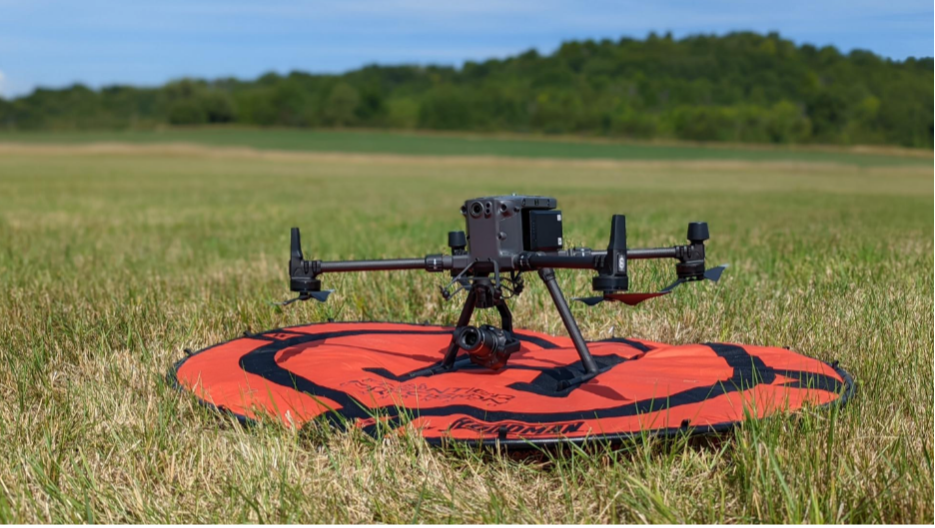
Bessie Flyson, named after Bessie Coleman, the first African American woman and first Native American to hold a pilot license. She’s a Matrice 300 RTK (Real-time kinematic) Quadcopter equipped with an interchangeable RGB camera and can collect orthomosiac imagery with sub-meter level accuracy due to her RTK capabilities. Digital elevation and surface models, point clouds, and contour lines can be derived from her imagery. She can take high quality videos, oblique photos and can fly in large areas for long periods of time.
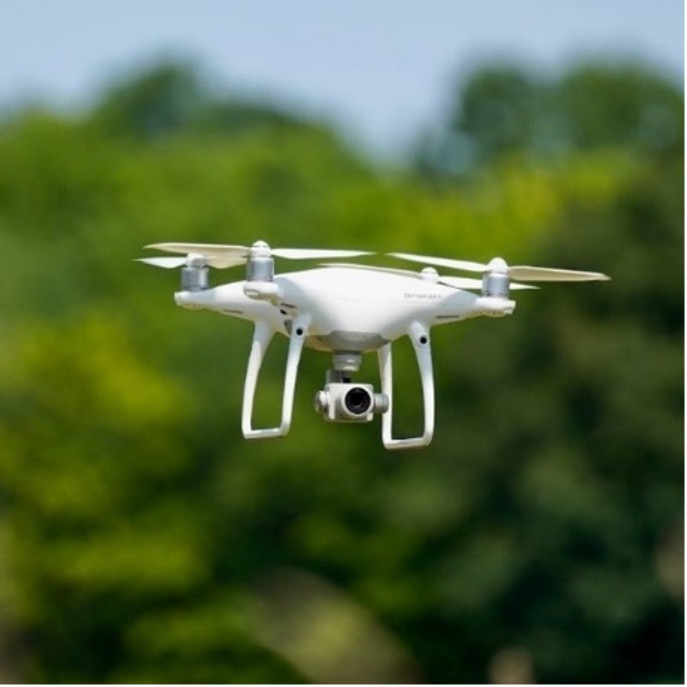
Rachel Flyson, fondly named after biologist Rachel Carson, is a DJI Phantom 4 Pro V2.0. Like Bessie, she collects RGB orthophotos, digital elevation and surface models, point clouds, contour lines, videos and oblique photos. She’s significantly smaller than Bessie, allowing for better use in narrow areas and for surveying smaller areas. However, she’s not RTK equipped and has a significant less amount of flight time per battery.
Check out our StoryMap for more information.

Project Partners:
Current U.S. Department of Agriculture-Natural Resource Conservation Service (USDA-NRCS) drone policy is based upon rules and regulations from USDA, Federal Aviation Administration (FAA), General Services Administration (GSA) and Congress. While USDA-NRCS is not permitted to own or operate UAV technology, it can partner with outside entities, like Natural Resources Conservation Districts, to operate drones on their behalf and in support of Farm Bill programs. VACD functions as the owner and operator of the UAVs. The program enters into an annual agreement with NRCS regarding the scope and scale of UAV activities in exchange for NRCS providing staff funding support, office storage space, and conservation project proposals. This VACD-NRCS program partnership is unique within USDA-NRCS and has received national recognition for its innovation.